How satellite intelligence is reshaping mining decision-making
Published by Jody Dodgson,
Editorial Assistant
Global Mining Review,
Mining is in a period of expansion. Demand for critical minerals remains strong; metal prices have supported investment, and there is renewed focus on secure supply chains.
That growth has not made project delivery simpler. New deposits are deeper, grades are lower, scrutiny is higher, and capital is harder to access on favourable terms. Even technically sound projects can struggle once timelines stretch, and early assumptions shift.
Mining decisions are driven by data at every stage, from target selection through to operations and closure. As projects become more complex, the challenge is less about access to information and more about knowing what has changed, where, when, and what it means. Geological interpretations, engineering plans, environmental studies, and production reporting all move at different speeds. As projects scale, teams often work with accurate information that is contextually incomplete.
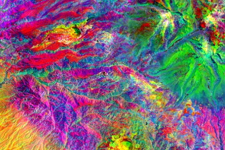
This is where satellite intelligence plays a practical role with providers such as EarthDaily supporting continuous external visibility as projects move from exploration through to closure.
Exploration: narrowing uncertainty
Exploration teams are covering more ground while advancing fewer targets. In that environment, reducing uncertainty early matters. Satellite intelligence is most effective when used early and iteratively, testing hypotheses quickly, discarding sub-optimal ideas, and prioritising targets that align with exploration strategy.
In practice, this includes screening large areas before committing in-country spend, identifying lithologies and alteration patterns associated with known deposits, learning from existing economic projects, and flagging land use, demographic, and environmental constraints early.
The benefit is not limited to target generation. That broader concept helps ensure that land use, infrastructure, and population patterns shape decisions early.
Development: building evidence that carries forward
As projects progress, scrutiny follows. Community concerns, stakeholder expectations, regulatory oversight, and closure obligations tend to accumulate rather than reset at each stage. What changes is the need to explain what is happening on the ground, why, and with what impact.
Risk emerges when baseline conditions cannot be tracked consistently over time, making it difficult to distinguish mining-related impacts from broader land use or community change. That ambiguity lends itself to reactive compliance discussions, hardens community narratives, and forces questioning the validity of early-stage assumptions.
Independent, continuous visibility reduces that risk. A running record of land cover, landform, infrastructure, and community change provides evidence that can be carried from development into operations and closure. It supports clearer attribution of change, more defensible engagement, and better-informed decisions around progressive rehabilitation and long-term land performance.
Operations: managing change early
During operations, risks often develop gradually. Ground deformation, land encroachment, surrounding infrastructure growth, or nearby artisanal mining (ASM) activity can become material without visibility.
At that point, focus on in-situ monitoring alone struggles to provide broader visibility of operational, environmental, and community exposure. Satellite intelligence helps by avoiding unauthorised land clearing, identifying risk to critical infrastructure, supporting earlier engagement around ASM activity, and providing continuous external context that strengthens interpretation of site-based data.
Disclosure and accountability
Accountability is no longer defined solely by what a company chooses to disclose. Satellite imagery is widely accessible, and external stakeholders increasingly form their own views of mining activity using independent data. Tailings pond water extent, tailings wall stability, pit extensions, delayed rehabilitation, or construction activity are visible beyond the fence line.
When companies lack their own consistent record of change, they are left responding to external interpretations built from partial context. That can escalate concern, trigger compliance questions, or undermine confidence in stated performance. Maintaining independent visibility allows companies to engage in equal footing, using evidence rather than explanation. Earlier visibility matters because it allows issues to be understood and addressed before narratives harden, and options narrow.
Author bio
Steve Davis is Director Mining and Energy Development at EarthDaily. He is a mining transformation and strategy expert, currently leading global market engagement for EarthDaily's mining technologies.
Read the article online at: https://www.globalminingreview.com/special-reports/04022026/how-satellite-intelligence-is-reshaping-mining-decision-making/
You might also like
Liebherr sees stable growth in the 2025 business year
The Liebherr Group saw stable growth overall and ended the 2025 business year with a revenue of €14 772 million.