American Pacific Mining nears completion of underground LiDAR survey to advance Madison Project development
Published by Jody Dodgson,
Editorial Assistant
Global Mining Review,
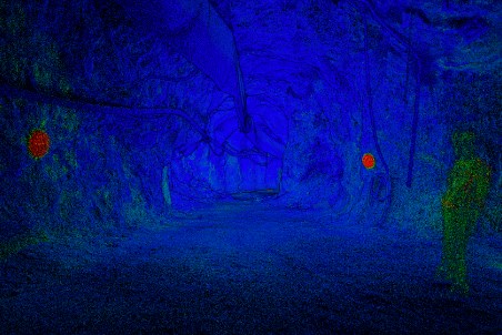
The company has engaged Water & Environmental Technologies, Inc. (WET), in collaboration with Dengel Surveying, to complete a high-resolution control survey and LiDAR scan of the historical Madison Mine underground ramp. The programme is designed to provide critical spatial data to support ongoing geological modelling, targeting, and future drill planning.
Survey programme overview
The scope of work includes two primary components:
Control Survey
- Establishing precise underground and surface control points.
- Integrating surface control with underground survey control to ensure spatial accuracy.
- Traversing the decline to approximately 800 ft from the mine entrance, near the current water level.
LiDAR Ramp Scan
- High-resolution 3D scanning of the underground ramp using the Emesent HVM100 system, designed for GPS-denied environments.
- Placement of reflective targets to accurately geo-reference the dataset.
- Generation of:
- Geolocated point cloud.
- 3D mesh model.
Field work is expected to be completed in April 2026, with final deliverables anticipated within approximately three weeks following completion of field activities.
“This underground LiDAR survey is critically important as it’s the first dependable underground dataset ever amassed at Madison uniting the various historical survey methods into one accurate and verifiable package”, commented Managing Director of Exploration, Eric Saderholm. “With improved underground access caused by receding water, our team has seized the opportunity to rectify and eliminate any previous errors and variances in the available data, both surface and underground. The importance of this procedure for modelling, drilling and future mineral inventory calculations cannot be understated.”
Read the article online at: https://www.globalminingreview.com/exploration-development/29042026/american-pacific-mining-nears-completion-of-underground-lidar-survey-to-advance-madison-project-development/
You might also like


The role of business aviation in Chile’s mining industry
Ricardo Real, CEO at Aerocardal, highlights the increasing importance of aviation for the mining industry , and its role in facilitating access to remote mining operations.