Sandvik introduces My Sandvik Geo – real-time geological insight for more efficient and safer mining operations
Published by Jody Dodgson,
Editorial Assistant
Global Mining Review,
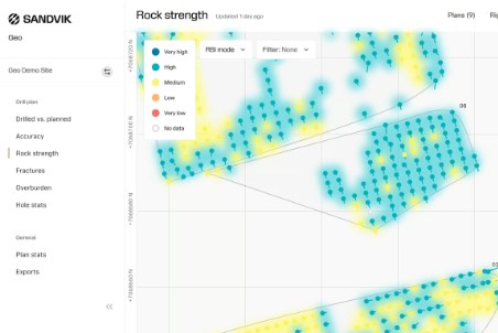
The solution provides mining operations with near real-time visibility into subsurface conditions, enabling smarter planning, improved blasting outcomes and enhanced overall productivity in surface top-hammer drilling.
As mining operations work to boost efficiency and reduce operational risks, the ability to understand rock conditions quickly and accurately has become critical. My Sandvik Geo processes raw drilling measurements - including Measure While Drilling (MWD) data and drilling coordinates - and converts them into meaningful insights, such as rock strength, fractures, overburden, drilling accuracy, and plan vs. actual execution.
From drilling data to wisdom
My Sandvik Geo organises drilling data into four clear stages. It starts with raw signals captured from the rig, forming the Data level. These signals are then processed into values, such as rock hardness, discontinuities and overburden, which make up the Information level. From this, the platform generates geological models within My Sandvik, creating the Knowledge level. Finally, it delivers actionable recommendations that guide strategic decisions and support continuous improvement at the Wisdom level. This progression enables geologists, blast engineers, planners and supervisors to optimise operations with confidence.
Key benefits for mining operations
My Sandvik Geo delivers key improvements across drilling and blasting. It enables optimised blasting through accurate rock-strength identification, improves safety by revealing fractures and voids, enhances drilling quality with detailed accuracy insights, and supports more efficient use of explosives and materials. It also provides real-time visibility into deviations from the blast plan, helping teams adjust quickly and maintain high standards. The service integrates smoothly with Sandvik’s cloud-based digital ecosystem and exports data to leading mine-planning software, like Deswik. Activation is simple, and once enabled, drilling data flows automatically to the cloud for easy visualisation.
Read the article online at: https://www.globalminingreview.com/mining/02032026/sandvik-introduces-my-sandvik-geo-real-time-geological-insight-for-more-efficient-and-safer-mining-operations/
You might also like
Jameson Cell expands into rougher duties to boost plant efficiency amid rising global demand
As global demand for mineral resources grows and operating constraints tighten, Glencore Technology offers the Jameson Cell – the flotation solution delivering greater performance and efficiency when the industry needs it most.